
Nederlandse versie van dit artikel door hier te klikken
There’ll be bluebirds over
The white cliffs of Dover
Tomorrow
Just you wait and see
There’ll be love and laughter
And peace ever after
Tomorrow
When the world is free

This is how Vera Lynn sang about the White Cliffs of Dover during the Second World War. Symbol of England, symbol of home for the British soldiers who fought overseas. The Romans saw them when they crossed the sea. Julius Caesar was impressed by this great defence, which made it difficult for him to find a place to go ashore. In his report he wrote that the coast was unsuitable for landing. He sailed on and finally found a place to land north of Dover. Shakespeare found inspiration in the cliffs and wrote about it in his well-known work “King Lear”. Shakespeare Cliff near Samphire was named after him because of that. It is not surprising that the impressive high cliffs have played an important role in the defense of the British isle since prehistoric times.
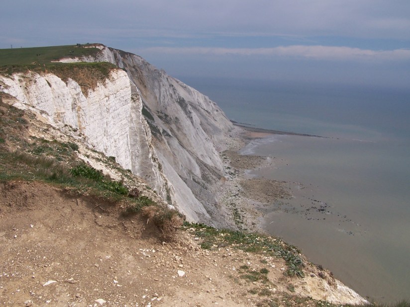
Iconic … you travel by ferry from Calais or Dunkirk across the Channel to England and the first thing you see are those iconic White Cliffs of Dover. Subject of books, films, songs and poems. They spark people’s imagination. The entrance to England. The White Cliffs of Dover.
They are always there. Sometimes you already see them when you leave France and sometimes you see nothing until just before you enter the harbour because they are covered in fog. Albion, the first name to describe England, is said to have come from the name of a Celtic tribe. But the Romans made the link with albus, their Latin word for white, and the White gateway to this island.
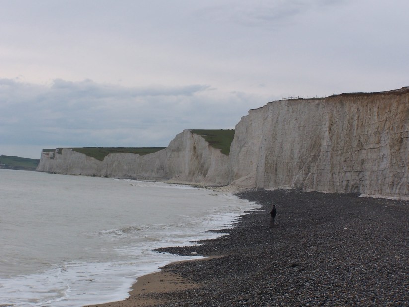
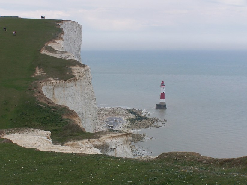
They have been there for a long time, those cliffs. The shortest crossing over the sea to England and then you stand eye tot eye with this high barrier. Many people who have tried to conquer or colonize England have seen the cliffs and may have wondered why this island seemed so inaccessible, what was hidden behind the high white rocks. And they are pretty high. At Dover, the highest cliff rises 110 metres above the sea. But that is not the highest point of the white cliffs, that is at Beachy Head where the cliff are 162 metres high. The cliffs are part of the North and South Downs. A limestone area in the southwest of England. The white limestone soil makes this area a special habitat for many chalk-loving plants that are rare elsewhere in the country. Two parts of the North Downs have been declared Areas of Outstanding Natural Beauty. The majority of the white cliff coast is protected as a Site of Special Scientific Interest (SSSI). The name Downs comes from the Old English word for hill, dun. The North Downs are in Kent and Surrey and the South Downs in Sussex and Hampshire. In fact, this limestone package continues under the Channel and across the sea, in Normandy you see the rest of this chalk formation.
The Downs were formed during the geological period we call the Cretaceous. This period, which comes after the Jurassic and is part of the Mesozoic, began some 145 million years ago and ended with the famous meteorite impact that ended the rule of dinosaurs on earth 66 million years ago. The white cliffs have been formed in a number of epochs within this Cretaceous. The oldest layers are the Greensand layers from the Upper Greensand formation. The name says it all, the sandstone in this formation is somewhat greenish in colour. These layers were formed in the Albian and the Cenomanian, which makes them between 113 and 95 million years old. This rock is not white, but lies beneath the white lime and comes to the surface here and there. The Chalk Group lies on top of the Upper Greensand and this is the rock formation to which the typical white chalk belongs. The Chalk Group has recently been subdivided into two subgroups, the White and the Gray Chalk subgroup (previously named Lower, Middle and Upper Chalk). These subgroups are in turn subdivided into formations. The age of the chalk deposited in this period varies from the beginning of Cenomanian (100 million years ago) to the end of Maastrichtian (66 million years ago).
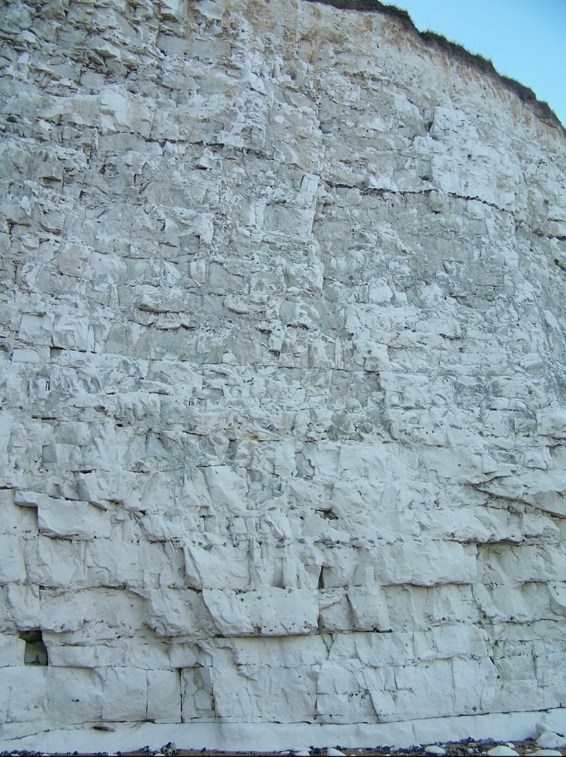
The Chalk, or limestone, itself consists for the most part of the mineral calcite. Not in crystal form, but as the tiny building blocks of chalk. You can read more about calcite as a mineral here. It is actually a very freakish type of stone. It is a kind of mass grave of billions of tiny single-celled algae, called coccolites. Or rather, the calcite plates of their external skeletons. During the Cretaceous period, the vast majority of the area that is now England, but also the Netherlands, parts of Germany, Denmark, Belgium and France were sea. It was a bit warmer than today and the sea level was about 100 metres higher. Innumerable single-celled algae lived in this sea, which after they died sank to the bottom where the calcite plates of their external skeleton very slowly became an increasingly thick layer. So slow that the theory nowadays is that an average of half a millimetre was deposited per year. And now realize yourself that there are places where this package of Chalk is 500 meters thick… This coccolite sludge changed under pressure into chalk rock and at the end of the Cretaceous the whole package was lifted by the same tectonic movement that also created the Alps. For a long time, England and ‘the continent’ have been connected by land. The Chalk package ran from England to France and the Channel did not exist. The southern North Sea wasn’t connected with the Atlantic Ocean that was in the process of forming. Roughly from the area around Hastings to Boulogne-sur-Mer there was a harder and older type of rock from Jura and Carboniferous period beneath the soft chalk package that had been lifted and prevented the Channel from breaking through between England and France. We call this the Weald-Artois anticline. Sea and rivers caused erosion of the soft Chalk package, except here. When in the Pleistocene the north of Europe was covered with ice glaciers, a meltwater lake was created between this ice and the land bridge. About 425 thousand years ago the water supply was so big that there must have been a gigantic waterfall at the land bridge between present-day France and England, with millions of cubic metres of water per minute falling down into the lower lying Atlantic Ocean. Parts of the land bridge were probablydestroyed by the forces of nature and narrow passageways were created for the water. Some 225 thousand years ago, the land bridge finally broke through and the first Brexit took place. Great Britain got separated from mainland Europe.
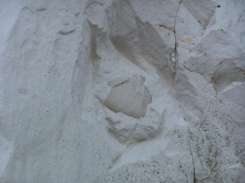
The entire Chalk coast is popular among fossil collectors because the white cliffs are particularly rich in beautifully preserved fossils. Many of them are sea urchins, starfish and bivalves. But you can also find ammonites and even shark teeth in places. The cliffs are also the main supplier of flint.

Regular, horizontal, black bands run through the white chalk. These bands consist of flint. Usually quite dark gray to black in colour. Over the years, these rock-hard flint layers erode out of the soft Chalk, which of course erodes much easier. This flint is found en masse on the beaches below the cliffs. Sometimes you see prints of fossils in the pieces of flint. This flint was gratefully used by our ancestors for making tools.
White Cliff country is in many ways a great destination to spend a few days. Of course it is a huge advantage that it is easily accessible from mainland Europe. Every day dozens of ferries depart from France to Dover, England (and back) and a crossing nowadays is not very expensive anymore. In addition, there is the Channel Tunnel for people who want to get across quickly or prefer not to cross the sea in a boat. If you travel through the Tunnel you miss the iconic view of the white cliffs with the beautiful view at Dover Castle on top of the cliff as the ferry enters the port of Dover, but it certainly is fast. In Kent are many beautiful places that are worth a visit. The entire Kentish coastline is amazing, towns to the north of Dover such as Broadstairs, Deal, Walmer and Sandwich are very cosy and everywhere you have a beautiful view at the cliffs. The last three towns have beautiful castles and in Sandwich there is even a Dutch influence. Here you can find the ‘Dutch House’.
Dover is, of course, a port where the castle is the biggest attraction. Take at least a few hours to visit the castle, because apart from the castle (the largest in Great Britain!) itself you can also view the history of both castle and cliffs as a stronghold and how they played a major role in the Second World War. Folkestone is also a fairly large town, but doesn’t really have an attractive town centre. But is is a nice town to do some shopping.
You can also take a walk on the beach to have a closer look at the cliff, but be careful. Chalk is a soft and porous rock, and often large parts of the cliffs collapse. This happens unexpectedly, without clear signs or warnings. And when it collapses, a lot of rock comes tumbling down. Especially after the winter with frost and rain, be careful if you want to walk on the beach. Most important, stay well away from the foot of the cliff and do not take any risks!
Further north the cliffs disappear and the estuary of the well-known river Thames begins (or ends, whatever way you look at it).
South of Dover lies the nature reserve of Samphire Hoe. This is a nice destination for a walk. What makes this place special is that this area was created quite recently. When the Channel Tunnel was excavated, they had to put the tons of Chalk that were brought up from the Tunnel somewhere. This was all deposited at a stretch of coast just south of Dover. Partly in the sea and partly on land. This ‘new’ country was named Samphire Hoe. Named after the plant Rock Samphire that grows on the Chalk, also known as sea fennel. Hoe is an old name for land extending into the sea. Opened in 1997, it is currently a nature reserve where you ramble and enjoy the typical chalk nature and scenery. Further south we leave Kent and the white cliffs disappear for a while and make way for a piece of old marshland, the Romney Marshes, and the old Cinque Ports of Rye and Winchelsea. Tot he west we see cliffs again, this time yellow and brown, the cliffs of the Weald, an area of lifted older Lower Cretaceous, at Hastings, the place where William the Conqueror began his conquest of Great Britain. If you follow the coastal route from Hastings via Pevensey in the direction of Eastbourne, you will see the imposing white cliffs of Beachy Head looming in the distance. These are the highest cliffs on the south coast and a major tourist attraction. If you are afraid of heights then this is a place that you might want to skip. At Beachy Head you also find the cliff formation that is called the ‘Seven Sisters’, because when you stand there on the beach you can see seven chalk hills and cliffs behind each other.
The coastal route takes you further along the coast, occasionally the white Cliffs make way for a seaside town, all the way up to Hampshire. Along the way you will pass seaside resorts that were once the elite places of the country in Victorian times, such as Brighton with the famous Brighton Pavilion and Pier, Bognor Regis and the major ports of Portsmouth and Southampton, from where ferries depart for France, the Channel Islands and the Isle of Wight (where you can also see beautiful Chalk cliffs). This coastal route is a nice alternative to a trip to the west instead of the highways that all take you around the London Orbital M25. But only if you have plenty of time. The coastal route is extremely busy in high season and traffic jams are frequent in summer, especially on the stretch between Brighton and Worthing. Nice stops along the route are also the town of Lewes with a beautiful old ruin on a hill and Arundel with its majestic castle.
White Cliff Country is a nice destination for a short break.

1 thought on “The White Cliffs of Dover”